Recuperando lo que parecía perdido: Posibilidades y perspectivas del uso de aerofotografías históricas en el registro de patrimonio natural y cultural
Por Abel Traslaviña
1. El Perú desde el aire: hitos en el uso de la aerofotografía en la investigación
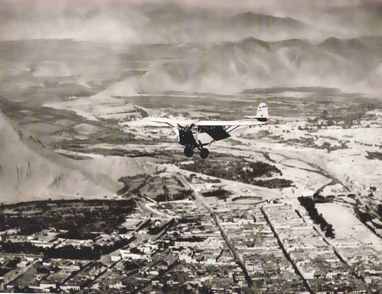
Luego del uso estratégico de la aerofotografía en acciones militares durante la Primera Guerra Mundial su aplicación se extendió a otros campos como la geografía y la arqueología. En este contexto, la Sociedad Geográfica Americana enfocó sus esfuerzos y recursos en proyectos y publicaciones sobre distintos lugares en los cuales poder aplicar esta nueva técnica para la investigación, siendo el Perú uno de ellos. Las primeras experiencias en aerofotografía en el Perú se remontan a finales de la década de 1920 cuando el Teniente George Johnson, miembro de la Sociedad Geográfica Americana, llegó al Perú para desempeñarse como Instructor en Aerofotografía en la Base Aérea Naval de Ancón entre el 15 de junio de 1928 y el 1 de enero de 1930 (Denevan 1993, Johnson 1930). Durante estos años, Johnson realizó una serie de vuelos exploratorios con el objetivo de registrar elementos característicos de nuestro variado territorio como los valles costeros, los desiertos y estribaciones andinas, los puertos y ciudades litorales, las planicies y valles altoandinos, las profundas gargantas de los ríos serranos, los conos volcánicos y los picos nevados, y la llanura amazónica y sus ríos tributarios. Si bien no se sobrevoló por completo el territorio peruano, la intención fue recoger en lo posible una muestra representativa de lo vasto y diverso de nuestros ecosistemas y sus texturas a través de una serie de notables fotografías aéreas, tanto verticales como oblicuas. Esta primera aproximación a nuestro territorio desde las aerofotografías recibió el nombre de Peru from the Air y fue publicada por la Sociedad Geográfica Americana en 1930.
Recovering what seemed lost: The potential of historical aerial photographs in the study of Peruvian heritage
By Abel Traslaviña
1. Peru from the air: milestones in the use of aerial photography for research
After the strategic use of aerial photography in military actions during the First World War, its application was extended to other fields such as geography and archeology. In this context, the American Geographical Society focused its efforts and resources on projects and publications on different places in which to apply this new technology for research, being Peru one of them. The first experiences in aerial photography in Peru date back to the late 1920s when Lieutenant George Johnson, a member of the American Geographical Society, arrived in Peru to work as “Instructor in Aerial Photography” at the Naval Air Base in Ancon. June 15, 1928 and January 1, 1930 (Denevan 1993, Johnson 1930). During these years, Johnson conducted a series of exploratory flights with the objective of registering characteristic elements of our varied territory such as coastal valleys and deserts, coastal ports and cities, high Andean plains and valleys, the deep gorges of the Andean rivers, volcanic cones and glaciers, and the Amazonian plain and its tributary rivers. Although the Peruvian territory was not completely overrun, the intention was to collect as much as possible a representative sample of the vast and diverse of our ecosystems and their textures through a series of remarkable aerial photographs, both vertical and oblique. This first approach to our territory from aerial photographs received the name of Peru from the Air and was published by the American Geographical Society in 1930.

